
About Us
About Yadgir
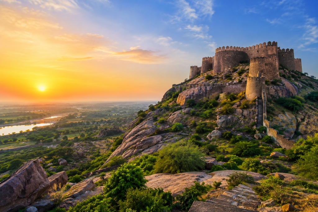
Yadgir, located in the northern part of Karnataka, is a land shaped by centuries of history, rich cultural traditions, natural landscapes, and a growing spirit of development. From its historic forts and architectural landmarks to its rivers, hills, temples, and vibrant communities, the district reflects a unique blend of Karnataka’s heritage and contemporary aspirations.Yadgir’s historical character can be seen in places such as Yadgir Fort, Shorapur Fort, and Vanadurga Fort, while destinations such as Basava Sagar Dam, Bonal Bird Sanctuary, and Sleeping Buddha Hill showcase the district’s natural beauty. The district is also home to important religious and cultural sites that attract visitors and connect communities with their traditions.Today, Yadgir continues to move forward with opportunities in agriculture, education, infrastructure, tourism, and local development.
A Glance at Yadgir
Ancient Roots
Discover prehistoric heritage, ancient settlements and fascinating Stone Age rock art found across Yadgir.
Daal Bowl of Karnataka
Known for its fertile black soil and significant red gram cultivation, Yadgir holds a special place in Karnataka's agricultural landscape.
Krishna & Bhima
The Krishna and Bhima rivers enrich the district's landscape, agriculture and communities.
Bonal Wetlands
Bonal Bird Sanctuary offers a peaceful habitat for diverse resident and migratory bird species.
Malakheda Stone
The distinctive Malakheda Stone adds to Yadgir's architectural, cultural and industrial heritage.
Industry & Growth
Growing sectors including cement, textiles, leather and chemicals contribute to Yadgir's economic development.
Why Explore Yadgir?
Historic Forts
Explore Yadgir, Shorapur and Vanadurga forts that reflect the district's rich history and architectural heritage.
Sleeping Buddha Hills
Discover the fascinating hills near Shahapur that naturally resemble a Buddha in a peaceful sleeping posture.
Bonal Bird Sanctuary
Experience a beautiful wetland surrounded by rocky landscapes and agricultural fields, home to many bird species.
Basava Sagar Dam
Enjoy the scenic beauty of the Krishna River and the expansive Basava Sagar reservoir surrounded by peaceful landscapes.
Sacred Heritage
Visit ancient temples, Basadis, dargahs and other spiritual landmarks that reflect Yadgir's diverse cultural traditions.
Daal Bowl of Karnataka
Discover Yadgir's agricultural heartland, known for its fertile black soil and important red gram cultivation.
History of Yadgir
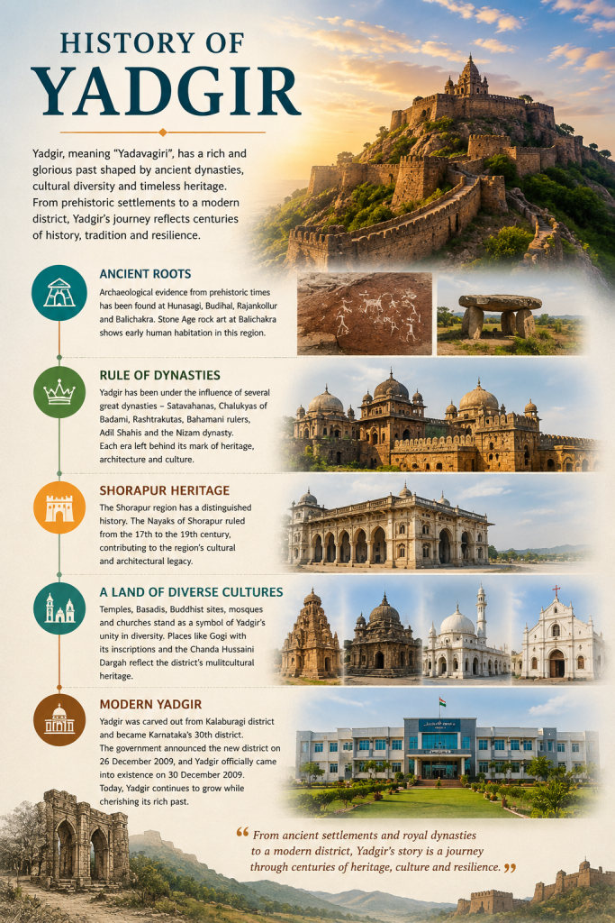
Yadgir, locally known as “Yadavagiri,” has a long and fascinating history shaped by several powerful dynasties and diverse cultural traditions. The region has been associated with the Satavahanas, Chalukyas of Badami, Rashtrakutas, Bahamani rulers, Adil Shahis and the Nizam dynasty, leaving behind a remarkable legacy of architecture, inscriptions, forts and religious centres.
Yadgir is believed to have served as a capital of the Yadava Kingdom, and the name Yadgiri appears in ancient inscriptions. The historic Yadgir Fort, situated on a hill, stands as an important reminder of the region’s strategic and architectural past. The neighbouring Shorapur region also has a distinguished history, with the Nayaks of Shorapur ruling from the 17th to the 19th century.
The district’s history reaches even further back into prehistory. Archaeological remains from the prehistoric period have been identified around Hunasagi, Budihal and Rajankollur, while Stone Age rock art has been found at Balichakra. These discoveries provide evidence of early human settlement in the region.
Over the centuries, Yadgir became a meeting point of different cultures and traditions. Its temples, Basadis, Buddhist centres, mosques and churches reflect the region’s diverse cultural heritage. Places such as Gogi, with its archaeological remains, inscriptions and Chanda Hussaini Dargah, further illustrate the layers of history preserved across the district.
The history of Yadgir continued through a succession of major political powers. In 1504, Yadgir and the surrounding region became part of the Adil Shahi Kingdom of Bijapur. Later, in 1657, the region came under Mughal influence following the campaigns of Mir Jumla. With the establishment of the Asaf Jahi Nizam dynasty of Hyderabad in 1724, Yadgir and the wider Gulbarga region became part of the Nizam’s dominions. These successive periods contributed to the architectural, administrative and cultural character that can still be seen across the region today.
Explore Yadgir Towns
Yadgir
Yadgir is the headquarters of Yadgir District and an important administrative, agricultural and commercial centre. The town is known for its historic fort and rich heritage.
Shahapur
Shahapur is an important town surrounded by agricultural landscapes and historic sites. The region is also known for its distinctive natural formations and cultural heritage.
Shorapur
Shorapur, historically known as Surpur, is renowned for its royal heritage and the legacy of the Nayaks of Shorapur. Its forts, palaces and historic landmarks form an important part of Yadgir's cultural identity.
Gurmitkal
Gurmitkal is an important agricultural and trading centre in Yadgir District. The town serves surrounding rural communities and contributes to the district's local commercial activity.
Hunasagi
Hunasagi is an important agricultural area of Yadgir District. The wider region is also associated with prehistoric archaeological heritage and a distinctive rural landscape.
Wadgera
Wadgera is one of the taluk areas of Yadgir District, with a predominantly rural landscape and an economy closely connected with agriculture and local communities.
Yadgir Population Growth
Yadgir District Statistics
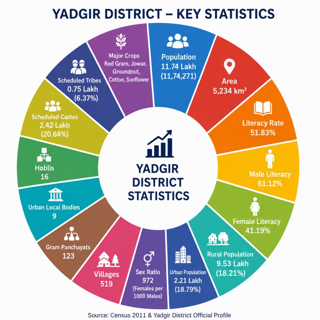
Yadgir is one of the smaller districts of Karnataka, covering approximately 5,234 sq. km and comprising six taluks — Yadgir, Shahapur, Shorapur, Gurmitkal, Hunasagi and Wadgera. According to the 2011 Census, the district had a population of 11,74,271, with a population density of about 223 people per sq. km and a literacy rate of 51.83%. Around 81.21% of the population lives in rural areas, reflecting the district’s predominantly rural character.
Agriculture plays a central role in Yadgir’s economy. The district has extensive fertile black-soil areas and is particularly known for red gram (tur), jowar, sunflower, groundnut and cotton. With around 75% of its geographical area under net cultivation, agriculture remains an important source of livelihood for its people. The Krishna and Bhima rivers, along with irrigation projects and tanks, support agricultural activities across different parts of the district.
Yadgir has 519 villages, 16 hoblis, 123 Gram Panchayats and 9 urban local bodies, highlighting its extensive rural and administrative network. The district also has a growing educational, commercial and public-service infrastructure. Its combination of agriculture, natural resources, historical heritage and developing infrastructure contributes to the distinctive character of Yadgir.
Area Measurement of Yadgir
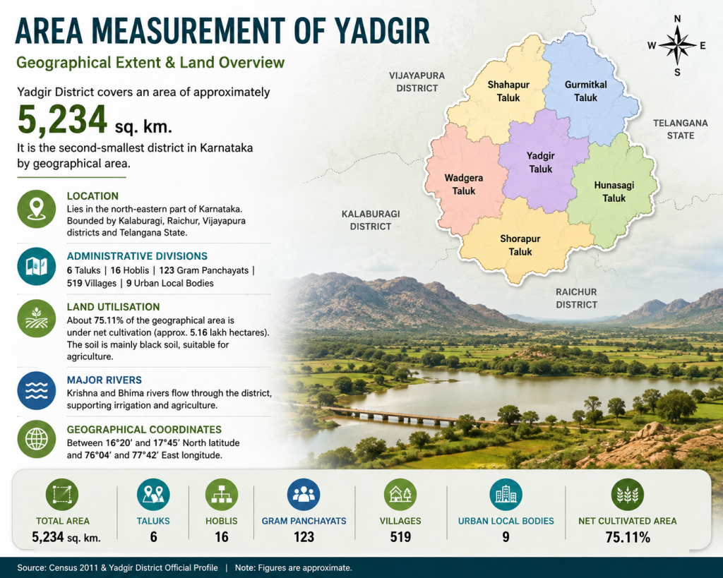
Yadgir District covers an area of approximately 5,234 square kilometres, making it the second-smallest district in Karnataka by geographical area. The district lies in the north-eastern part of the state and shares its boundaries with Kalaburagi, Raichur, Vijayapura and the neighbouring state of Telangana.
The district is spread across six taluks — Yadgir, Shahapur, Shorapur, Gurmitkal, Wadgera and Hunasagi. Administratively, the region is further organized into 16 hoblis, 123 Gram Panchayats and 519 villages, creating a wide network of rural settlements across its geographical area.
A significant portion of Yadgir’s land is devoted to agriculture. The district administration reports that about 75.11% of its geographical area is under net cultivation, covering approximately 5.16 lakh hectares. The landscape is characterized by fertile black soils, dry agricultural zones and the river systems of the Krishna and Bhima, which contribute to the district’s agricultural and ecological character.
Revenue and Economy of Yadgir District
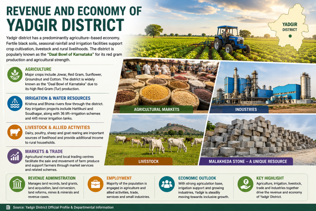
Yadgir’s economy is predominantly agriculture-based, with farming and allied activities providing livelihoods to a large section of the population. The district has extensive fertile black-soil areas and is divided into the North Eastern Dry Zone and Eastern Transition Zone, where agriculture is influenced considerably by seasonal rainfall. Jowar, red gram, sunflower and groundnut are among the major crops, while cotton is an important commercial crop. Yadgir is popularly known as the “Daal Bowl” of Karnataka because of its significant red gram production.
Irrigation and water resources play an important role in supporting the district’s agricultural economy. The Krishna and Bhima rivers flow through Yadgir, while irrigation infrastructure includes the Hattikuni and Soudhagar medium irrigation projects, 36 lift-irrigation schemes and 445 minor irrigation tanks. Although agriculture remains largely dependent on rainfall, irrigation facilities have helped expand cultivation in several parts of the district.